
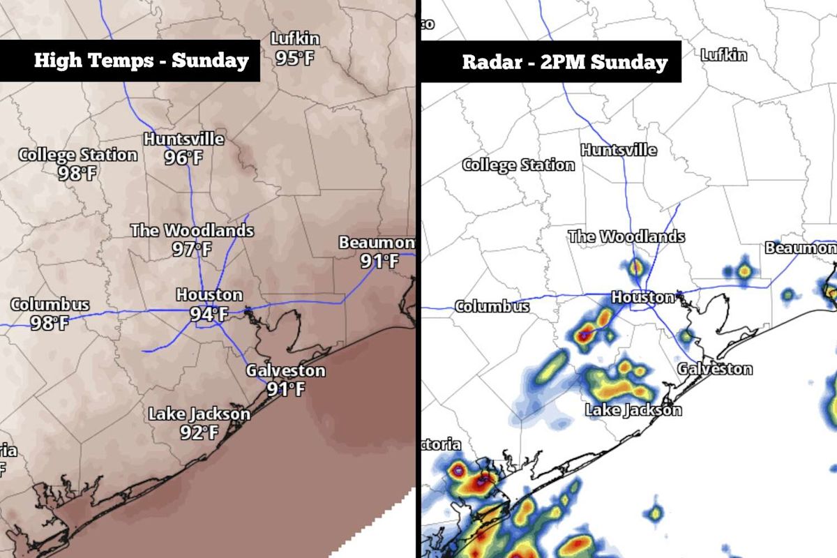
Residents across the greater Houston metropolitan area are preparing for a combination of intense late-summer heat and scattered thunderstorms on Sunday as tropical moisture pushes inland. While the incoming convective activity will not result in a widespread washout across Southeast Texas, atmospheric conditions are expected to trigger isolated downpours and gusty winds in select communities during the peak heating hours of the day.
The unsettled weather is being driven by a steady surge of rich Gulf moisture moving into the region from the southeast. Meteorologists note that because the storm activity will remain scattered rather than uniform, many neighborhoods across the metro area may stay completely dry. However, locations that do encounter storm cells could experience brief, localized deluges accompanied by strong wind gusts before the activity dissipates.
This window of potential precipitation follows an extended dry period that has affected Southeast Texas over the past two months. Although the region experienced a relatively rainy spring and an active start to the summer, rainfall totals have dropped off substantially since the middle of July. Regional climate data indicates that Houston has logged just 2.55 inches of precipitation since July 15, representing roughly 30 percent of the normal rainfall typically recorded during that timeframe.
Sunday will begin on an unseasonably warm and humid note across the urban corridor. Early morning low temperatures throughout the Houston area are forecast to hover near 80 degrees, which is significantly higher than the mid-September climate baseline. Under typical conditions for this point in the month, regional morning lows generally fall closer to a mild 72 degrees.
Following the warm start, temperatures are expected to climb quickly under strong morning sunshine. Weather projections indicate the mercury will likely reach 90 degrees as early as 11 a.m. By the early to mid-afternoon hours, ambient high temperatures are forecast to top out near 94 degrees, prolonging the stretch of unseasonable warmth across Southeast Texas.
When combined with the heavy Gulf moisture lingering across the area, the elevated ambient heat will generate oppressive conditions outdoors. Forecast models indicate that peak heat index values—the metric describing how hot the air feels when humidity is factored in—will reach between 103 and 105 degrees across Southeast Texas on Sunday afternoon, warranting caution for those spending extended time outside.
Atmospheric instability is anticipated to peak during the middle portion of the day as surface temperatures max out. Overall rain chances for the Houston metro area will sit between 30 and 40 percent, with the most favorable window for developing showers and thunderstorms concentrated between noon and 4 p.m.
As the afternoon progresses into the evening, the convective activity will steadily lose intensity. By the early evening hours, rain probabilities across the Houston area are expected to drop below 20 percent, allowing weather conditions to quiet down significantly as the sun sets.
Overall precipitation accumulations are projected to remain relatively light across the broader region. The vast majority of areas that see rain will likely record less than a quarter-inch of accumulation, though isolated spots beneath stronger convective cells could see localized amounts reaching a half-inch or slightly more. Given the dry antecedent conditions and modest rainfall projections, the flood threat across Southeast Texas remains very low.
Looking ahead to the upcoming workweek, persistent high pressure will maintain a firm grip on the region. A stalled high-pressure system situated just to the east will ensure that hot, humid, and largely stagnant conditions carry over into the first half of the week, suppressing any major change in air mass through at least Wednesday.
From Monday through Wednesday, Houston is forecast to experience daily high temperatures ranging from 92 to 94 degrees. Abnormally high humidity levels for mid-September will accompany the heat, driving peak afternoon heat index values up to between 105 and 107 degrees each day and reinforcing the late-summer feel.
Precipitation opportunities during the early workweek will remain quite limited. Forecasters anticipate only isolated, brief afternoon showers and thunderstorms from Monday through Wednesday, with daily rain chances hovering between 20 and 30 percent across the metropolitan area.
A minor transition in the broader weather pattern is projected toward the end of the week. The dominant ridge of high pressure is forecast to weaken slightly by Thursday and Friday, allowing afternoon high temperatures to ease slightly to around 91 or 92 degrees while daily rain chances increase marginally.
By next weekend, long-range weather models suggest that a potential cold front could track southward into the state of Texas. However, forecasters caution that the boundary is likely to stall out before it reaches the Houston area, meaning it will likely fail to bring any substantial temperature relief, though a few scattered storms will remain possible as the front nears the region.
For the immediate future, Southeast Texas will remain in a summerlike regime defined by elevated heat, oppressive humidity, and intermittent, localized storm chances. While Sunday’s scattered showers will provide temporary relief to isolated neighborhoods, widespread rainfall and true autumnal cooling remain on hold.







(0)