
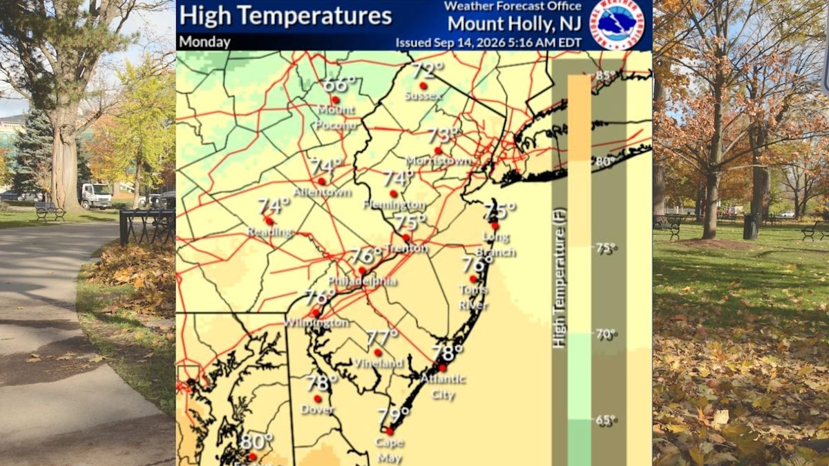
New Jersey is experiencing a classic stretch of pleasant late-summer and early-autumn weather this week, as tranquil atmospheric conditions, bright sunshine, and comfortable temperatures settle across the entire Garden State on Tuesday. The opening half of the week is offering residents an extended break from stormy weather, providing ideal conditions for outdoor activities and travel.
According to regional forecast data, daytime temperatures on Tuesday are anticipated to reach the mid- to upper 70s throughout the vast majority of central and southern New Jersey. In contrast, communities situated in the higher elevations of the northwestern counties will see slightly cooler conditions, with afternoon highs topping out in the comfortable lower 70s under cloudless skies.
A particularly notable feature of Tuesday's weather pattern is the presence of crisp, dry air. With humidity levels remaining comfortably low across all twenty-one counties, the outdoor climate is exceptionally refreshing. Meteorologists confirm that this stable, rain-free pattern is well-established and will keep dry weather firmly in place across the region through at least Thursday afternoon.
As the midweek approaches, the local atmosphere will experience a noticeable shift in temperature. Forecasters project that high pressure will facilitate a steady warming trend beginning on Wednesday, pushing afternoon highs into the low to mid-80s while mostly sunny skies continue to dominate the statewide horizon.
The unseasonable warmth will persist into Thursday, with maximum temperatures once again peaking in the low to mid-80s across most inland and coastal communities. However, unlike the crisp air observed during the early part of the week, Thursday will bring a noticeable rise in atmospheric moisture, resulting in increasing humidity levels that will make the air feel considerably more muggy.
The prolonged dry spell will encounter its first disruption late Thursday night and into early Friday morning. A weak cold front is scheduled to track across the northeastern corridor, bringing the potential for unsettled weather to brush against parts of the Garden State overnight.
Despite the arrival of the frontal system, forecasters from the National Weather Service emphasize that precipitation will likely remain limited in scope. While a chance of scattered showers exists for select portions of the state during the overnight hours, large areas of New Jersey are projected to miss the rain entirely and remain completely dry.
As the weak front departs on Friday, fair weather is expected to quickly reassert itself across the region. Friday afternoon will bring a return to mostly sunny conditions, accompanied by daytime highs that once again rise into the low to mid-80s, offering a warm and bright conclusion to the standard workweek.
Looking ahead to the upcoming weekend, forecasters are tracking a split pattern that will feature distinctly different conditions between Saturday and Sunday. Saturday is shaping up to be the highlight for outdoor recreation, featuring predominantly sunny skies, pleasant breezes, and seasonable afternoon temperatures settling back into the comfortable 70s.
The tranquil conditions will begin to break down by Sunday morning as an approaching weather disturbance spreads thicker cloud cover across the region. The increase in cloudiness will mark the end of the region’s multi-day sunny streak and signal the arrival of a more active weather pattern for the close of the weekend.
Accompanying the overcast skies on Sunday will be an increased probability of precipitation. Forecasters expect scattered showers to develop across New Jersey, with the potential for embedded thunderstorms to emerge throughout the afternoon and evening hours before continuing into Monday.
While meteorologists caution that there remains some inherent uncertainty regarding the exact path, timing, and precipitation totals associated with the weekend storm system, they emphasize that severe weather is not anticipated. The system is expected to produce standard rain showers rather than damaging winds or severe localized impacts.
This dynamic transition between late-season warmth, dry stretches, and intermittent rainfall coincides with the early stages of the autumn foliage season. Recent seasonal reports suggest that leaf color displays may vary noticeably across New Jersey this year, with foliage predicted to appear somewhat dull in certain sectors while other regions are anticipated to showcase vibrant, high-quality colors.
In summary, Garden State residents can look forward to capitalizing on several consecutive days of dry, warm, and mostly sunny weather through the middle of the week. Commuters, outdoor planners, and weekend travelers are advised to enjoy the favorable conditions through Saturday while keeping an eye on updated forecasts regarding Sunday's rain chances.


(0)