
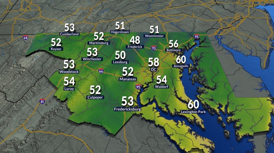
Residents across the greater Washington, D.C., metropolitan area awoke Tuesday morning to an unmistakable taste of the approaching change of seasons, stepping out into crisp, refreshing air that delivered the region's first genuine preview of fall weather. Following months of persistent summertime warmth and heavy humidity, the noticeable morning chill provided a welcome and brisk departure for morning commuters, students, and outdoor workers traversing the District, Northern Virginia, and suburban Maryland.
Early morning temperatures dipped comfortably into the 50s throughout the capital region during the Tuesday morning commute. The sudden plunge in morning readings marked a sharp contrast to recent conditions, prompting many local travelers to reach for light jackets, cardigans, and windbreakers for the first time since the early days of summer.
Meteorological data reveals just how substantial this cool morning milestone was for the Washington area. Prior to Tuesday, the last time the nation's capital recorded morning low temperatures falling into the 50s was back on June 3. That three-month span without a 50-degree reading underscores the prolonged grip of summer conditions across the Mid-Atlantic, making Tuesday’s cool dawn a notable seasonal turning point.
Despite the jacket-worthy start to the day, temperatures rebounded significantly as the sun climbed higher in the sky. Driven by abundant solar heating and very dry air, afternoon highs were projected to settle comfortably between the upper 70s and lower 80s across the region, creating nearly picture-perfect conditions characterized by low humidity and expansive sunshine.
Weather forecasters noted that the low humidity levels accompanying Tuesday's sunshine provided an optimal setting for regional outdoor activities, dining, and exercise. Because dew points remained comfortably low, the mild afternoon heat felt notably gentle, though meteorologists cautioned that this crisp and comfortable weather pattern would prove relatively short-lived.
The pleasant weather is slated to persist through midweek, giving area residents another opportunity to experience favorable late-summer conditions on Wednesday. The day is expected to start on another crisp note, though overnight low temperatures will not be quite as cool as the levels observed during Tuesday’s early morning hours.
As Wednesday afternoon unfolds, temperatures are forecast to climb slightly higher than those seen on Tuesday. Highs are projected to peak in the lower to mid-80s under predominantly sunny skies, maintaining a comfortable and dry atmosphere throughout the Washington metropolitan region for a second consecutive day.
Forecasters are advising residents throughout Maryland, Virginia, and the District to take full advantage of both Tuesday and Wednesday while the pleasant weather holds. The comfortable atmospheric regime is poised to give way by the latter half of the work week as a stronger surge of heat and moisture makes its way back into the Mid-Atlantic corridor.
By Thursday, a noticeable pattern shift will begin to take hold across the region. Higher atmospheric humidity levels will return, filtering in alongside partly sunny skies and pushing afternoon high temperatures back up into the upper 80s, signaling a rapid return to more typical late-summer mugginess.
The late-week warm-up will culminate on Friday as an unsettled weather dynamic develops across the eastern United States. A cold front tracking from the northwest will approach the Mid-Atlantic region, colliding with the increasingly hot, moist air mass firmly established over the capital area.
Friday’s forecast calls for daytime highs to hover once again in the upper 80s amid elevated humidity levels that will make outdoor conditions feel substantially heavier. As atmospheric instability increases during the heating of the day, isolated showers and thunderstorms are expected to develop during the Friday afternoon and evening hours ahead of the advancing frontal boundary.
Behind the cold front, conditions will moderate slightly over the upcoming weekend, bringing afternoon highs back into the mid-80s on both Saturday and Sunday. While the boundary will take the edge off Friday's peak warmth, it will not completely clear the area of atmospheric moisture.
Precipitation chances will remain present throughout the weekend, though Sunday is currently expected to feature the higher probability of scattered showers and thunderstorms. Weekend planners and outdoor event organizers are encouraged to stay updated on the latest localized forecasts as the timing of Sunday's unsettled weather becomes clearer.
Looking ahead to next week, the region is projected to kick off the new work week with high temperatures settling around 80 degrees under mostly cloudy skies on Monday. This mild and transitional weather setup serves as the final lead-in to next Tuesday, which marks the official calendar beginning of autumn and the formal start to the fall season across the region.







(0)